|
How to surf on the
site : Clic
on the selected sensitive button.
![]()
Contents of the page : the river Dropt - The Dropt basin - climate - searching for the Dropt
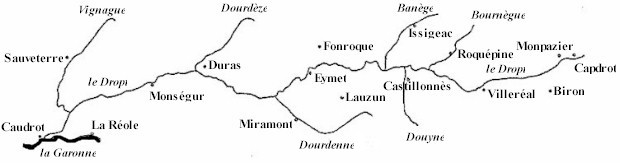
The river Dropt :
The
Dropt (pronounce “dro”)
or Drot is an affluent of the right bank of
the Garonne, between the Lot up-stream and the Dordogne down-stream. Most
important affluents : Bournègue,
Banège, Dourdèze, Vignague,
for the right bank ; Douyne, Dourdenne
for the left bank.
The
Dropt springs up at the bottom of a 239 metres high hill, in the massif situated
between the great valleys of the Lot and of the Dordogne. It flows from east to
west from Capdrot (the head of the Drot : “lou cap del Drot” in langue
d’oc or “caput Drotii” in Latin) to Caudrot (the tail of the Drot : “la
couau del Drot” in langue d’oc or “cauda Drotii” in Latin).
To
its natural Caudrot mouth, two Dropt – Garonne links are added : the Escourret
branch of Gironde-sur-Dropt (open in 1768 by a sudden rising of the Dropt) and
the Casseuil canal with a lock-gate, open during the XIXth century for the
navigation needs of the Dropt, up-stream of the last dam before the Garonne.
The
very slight slope between its spring and its mouth (150 metres difference in
level for 125 km) makes the Dropt a peaceful, winding, open-country river,
entirely bordered with trees. From the spring to the junction with the Garonne
is a series of dams with their ancient mills, including smaller mills along the
affluents.
For
agricultural needs (irrigation), reservoir lakes – the Brayssou lake (60ha) at
Parranquet, the Ganne Lake (40ha) at Tourliac, the Nette lake (27 ha covered, 1
200 000
m3) at Cavarc, the Graoussettes lake (36 ha) along the Dourdenne at Saint-Colomb-de-Lauzun,
the Escourroux lake (112 ha) near Eymet – sustain the water level (much
diminished by the harnessing of the Brame spring, near Monpazier, used for water
conveyance) and reduce rises in water levels.
In
the XIXth century, the Dropt made a navigable waterway down-stream from Eymet,
used for transporting goods. At the time when the great evolution of transport
means occurred, the Dropt carried ships from Eymet to its mouth. This activity
has completely disappeared. The Eymet “harbour” is well preserved, “Quai
de la navigation”.
Its basin covers nearly 1 500 km2 in Guyenne, from the Quercy to the Bordelais, borderline with the Haut-Agenais and the “purple” Périgord. Along its first half, the Dropt approximately follows the partition line between the “départements” (counties) of Dordogne and Lot-et-Garonne ; its course finishes in the Gironde. In 1999, the population of the 9 “cantons” (districts) which constitute the Dropt basin was 41 454 inhabitants, about 27,5 inhabitants / km2 (half the population density of the Lot-et-Garonne county). The absence of a town, even only “medium sized”, in the Dropt basin increases the rural character of this region. Miramont-de-Guyenne and Eymet appear as capitals with respectively 3 360 and 2 552 inhabitants… The other “urban centres” reckon with 1 000 to 1 500 inhabitants.
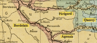 Notice on this ancient map ( Atlas 1922 edition) the spelling “Drot”, which is also found in Capdrot and Caudrot. The origin, fairly recent (XVIIIth century ?), of the change in spelling from “Drot” to “Dropt” is unknown.
|
The
alluvial plain in itself is of modest proportions (around 1 km wide at half
course). It is in general bordered on either side by "boulbènes"
terraces; then come molassic
foothills with a few hillocks or the edges of chalky plateaux. The nature of the
ground gives the basin its agricultural inclination.
![]() Top
of page
Top
of page
Climate :
Winter
is mild (stark cold and snow are exceptional) and damp (fog and drizzle).
Spring is the rain season (nearly half the annual precipitations).
Summer is dry and warm, unpleasant by stormy weather.
Autumn (October) may be the most pleasant period : still dry, warm, with a
beautiful light. Stendhal used to compare the Agenais with Toscany….
![]() Top
of page
Top
of page
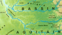 Find the Dropt on this map... (I.G.N France Physique) |
Some
reasons for such contempt :
-
Unfortunately, the Dropt belongs to the group of affluents of the right
bank of the Garonne, numerous, coming from the Pyrenees (Ariège) or the Massif
Central (Tarn, Lot, Dordogne), long, powerful, of great renown for tourists
thanks to the gorges of their upper parts. They have all given their name to a
county.
-
The Dropt is a relatively short, flat open country river, unique of its
type on this bank ; it crosses no important town, no scenic road runs along it ;
the Dropt does not yet exist as a county.
What
if this modesty made its charm…
![]() Top
of page
Top
of page
![]()