|
How to surf on
the
site : Clic
on the selected sensitive button.
![]()
End of the XVIIIth century : a rich region, very rich, but landlocked ; the
Bordelais trade ready to work this juicy seam ; a river flowing in the right
direction, “obvious” circulation route for these riches … if it is made
navigable !
Contents of the page :
review of motives - historical review
of the works - exploitation of the "canal"
- epilogue
![]() A
navigable river
A
navigable river
Review
of motives :
In
italics : extracts of the Dropt Navigation Company archives (1850)
“There is no richer country than this valley. All around are meadows, hemp or
wheat land. On the plateaux, also well cultivated, cereal and vine have long
since replaced the forests that covered them initially.
Considerable
fruit tree orchards are to be noticed, and especially graft plum trees. Few
woods, little community land, not an hectare of moor or fallow land ;
everywhere, on the contrary, fine cultures with the small estate, infallible
sign of the earth’s fertility and the people’s affluence.”
At the end of the XVIIIth century, wealth is also great. The whole valley is
nonetheless in an unfavourable situation : situated at the end of three counties
(Gironde, Lot-et-Garonne, Dordogne), it doesn’t seem to be of real
significance to any of them. The action of the central administration is barely
felt : the material improvements (county roads [“départementales”],
by-roads [“chemins vicinaux”]) are all refused or postponed.
The
great means of success, of progress, of fortune, was the Dropt, because this
waterway made navigable was the only way that could connect this valley with its
natural market - Bordeaux.”
![]() Top
of the page
Top
of the page
Historical review of the
works :
Year
II of the Republic :
The “Third Estate Journal” (“Cahiers du Tiers Etat” – art. 57)
demanded that « the river Dropt be made navigable ». Lakanal, deputy
of Ariège at the Convention, official representative in Dordogne from October
1793 to august 1794, defends the project and wants “to
make the Dropt valley what the
Tempé
valley
was in Greece”. He orders both the
construction of locks to make the Dropt navigable up to Eymet and the studies
necessary to conduct navigation all the way to Castillonnez first and then to
Villeréal eventually.
Lakanal demanded – imposed even – the towns’ financial participation,
rallied the labour force and the equipment. The construction of dams, the
opening of towpaths, etc…, everything is started immediately, with an all
revolutionary activity.
In
1795, a dozen dams are finished. But on October 26th, the Convention
is dissolved ; Lakanal’s power was removed by these events and … all works
were abandoned. Partial and undefined navigation attempts were made between 1793
and 1820.
April
18, 1821 :
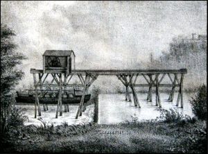 |
two lengthwise, horizontal and parallel pieces of wood, held up by piles driven into the river bed, respectively under and above the overflow ; a cart rolling in the groves made in these beams ; a system of winches linked to the cart allowing, with the help of chains, to lift a boat upstream (or downstream) above the level of the embankment, to shift it and to put it down again on the river downstream (or upstream). |
Two men could manage this manoeuvre which took about ten minutes.
Sir
Durassié and Sir Troquard and the Limited Company which succeeded them
effectively established navigation up to Eymet. The difficulties met in
operating this system were too many : considerable costs (two men required at
every dam for necessarily low tonnage boats) ; continual trials with the local
landowners to obtain a towpath ; lack of coordination in the operations because
the river was put up for rent in portions,
etc….
In
July 1833, the Company’s profit being near to nothing, a general meeting
decides to sell the equipment.
Many
problems remain :
-
the mouth
lock works are not yet started ; during the summer, there is not enough water
along the La Barthe-mouth part
and boats cannot reach the Garonne for 4 months in the year…
- the last two dams (Bagas and La Barthe) have to be raised by 0.7 metres.
 1858
:
1858
:
These
works are entirely finished and the Dropt is effectively navigable from
its mouth all the way to Eymet (about 70 km), even by the most dry weather
(drought in summer 1861).
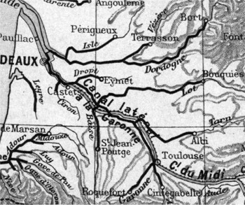
The opposite map (beginning XXth century) shows the navigable portions of rivers
in the South West of France. The very dense network proves the economic
importance of river transport at that time (river tourism was yet unknown…)
The New Dictionary of Universal Geography (started in
1875, published in 1894) is very critical as to the result of the operation in
the case of the Dropt : “It is the locks that
give the Dropt some depth and the appearance of a river (sic) ; because
in reality it is, despite the length of its course, only o brook with no
clearness, badly supplied by the sources of its basin.” (the
violence of the attack is surprising…).
![]() Top
of the page
Top
of the page
Exploitation of the "canal" :
The Dropt navigation Company,
concessionary for operating the “canal”, is authorized by the specifications
to collect a navigation fee, which protects it practically completely from the
competitive market.
The river is equipped with 38 dams and at
every dam 2 or 3 flour mills are set up ; hence the necessity to import wheat
(via the Dordogne, the Garonne, the Baïse and the Tarn).
Very rapidly the fleet is composed of 9 big
ships (the Dropt can carry 60 to 80 “tonneaux” ships) which generates in 1860 a movement of 273 221
tons (“Grand Dictionnaire Universel du XIXème siècle”, 1871
edition).
The
goods transported (1/5 for importation, 4/5 for exportation) : cereal, hemp,
wines (red and white), liquors, oils, dried prunes (10 000 tons sold on the
markets in 1860), timber (naval constructions, cartwrighting, heating), rubble
stones, tiles, bricks, etc…
The Dropt navigation Company then considers buying one or
two steam tugboats to tow convoys of 4 to 6 ships from the mouth of the
Dropt to Bordeaux, where a landing-stage / warehouse is already reserved on the
docks, upstream of the bridge. The development policy probably shows the
Company’s strategy : in case of compulsory purchase by the state or of the
construction of a railway, the compensation allowance, based on the Company’s
profits, will be much higher…
Because the menace is closer : a road following the Dropt
and linking together the towns of the valley has just been finished, a Marmande
– Bergerac link by rail which will follow the Dropt valley from La Sauvetat to
Falgueyrat and lastly the Eymet – Bordeaux link are planned.
The successive rescuers of the business (Sir
Deganne, then Sir Guerre, and finally Sir Boussang) are more interested in
collecting the toll money than in maintaining the river and the structures ;
they will all be deprived of their concessionary rights.
In 1892, after the final deposition of Sir Boussang, two
invitations to tender not being followed up, the Company looses all its rights :
the pieces of land bought, the works carried out and the equipments stocked up
become state property.
![]() Top
of the page
Top
of the page
Epilogue :
The road and rail transports will be
fatal to the circulation of goods on the Dropt.
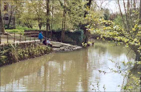
A badly thought out enterprise,
works disproportionate with the needs, will have led to an economic failure. The
Dropt today is back to a peaceful river where only a few small fishing boats and
canoes can be seen. The Garonne, the Lot, The Dordogne, the Isle, the Baïse
still have portions classified as “navigable” ; the Dropt isn’t
at all “navigable” any more…![]() Top
of the page
Top
of the page